Search Results
Showing results 1 to 5 of 5

Exploring Earth: Temperature Mapping
Source Institutions
This activity models the way Landsat satellites use a thermal infrared sensor to measure land surface temperatures.
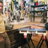
Model Wind Tunnel
Source Institutions
In this activity, learners build a miniature wind tunnel to measure force. Learners construct the model out of Lexan plastic, a fan, and a precise digital scale.
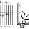
Topographic Investigation: Map an Underwater Surface
Source Institutions
In this activity, learners create a map of a hidden surface using a "sounding stick" -- a technique similar to how underwater maps were once made.

Pocket Solar System: Make a Scale Model
Source Institutions
This fun and simple hands-on astronomy activity lets learners build a scale model of the universe with little more than adding machine tape.
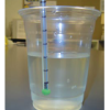
Water Body Salinities II
Source Institutions
In this activity, learners discuss the different salinities of oceans, rivers and estuaries.