Search Results
Showing results 1 to 4 of 4
Exploring Earth: Temperature Mapping
Source Institutions
This activity models the way Landsat satellites use a thermal infrared sensor to measure land surface temperatures.
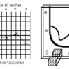
Topographic Investigation: Map an Underwater Surface
Source Institutions
In this activity, learners create a map of a hidden surface using a "sounding stick" -- a technique similar to how underwater maps were once made.

What's in the Water
Source Institutions
"What's in the Water" lets participants use tools to solve the mystery- what chemicals and compounds are in a sample of water?

Bubbles: Using Controls
In this experiment, learners use JOY liquid detergent and glycerin to make the largest bubble they can that lasts 15 seconds.