Search Results
Showing results 1 to 8 of 8
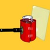
Turbidity
Source Institutions
This is an activity about turbidity, or the amount of sediment suspended in water.
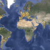
Globe at Night
Source Institutions
In this international citizen science activity, learners measure their night sky brightness and submit their observations into an online database.
Topographic Investigation: Map an Underwater Surface
Source Institutions
In this activity, learners create a map of a hidden surface using a "sounding stick" -- a technique similar to how underwater maps were once made.
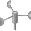
Paper Cup Anemometer
Source Institutions
In this meteorological activity, learners get to build their very own anemometer (instrument for measuring wind speed) using a paper cup.
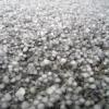
Sizing Up Hail
Source Institutions
In this activity, learners will estimate the sizes of balls to learn how to estimate the size of hail. Learners will compare their estimates to the estimates of their peers and the real measurements.
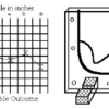
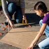
Radar Mapping: What's in the Box?
Source Institutions
In this activity, learners mimic remote sensing. Learners use a stick to measure the distance to a "planet surface" they cannot see, and create their own map of the landscape.
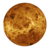
Ancient Sun Observations
Source Institutions
In this activity, learners make their own Sun tracker to explore how ancient civilizations around the world studied the Sun.
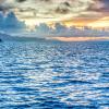
Water, Water Everywhere
Source Institutions
In this activity, learners estimate how much water they think can be found in various locations on the Earth in all its states (solid, liquid, and gas) to discover the different water ratios in the Ea