Search Results
Showing results 1 to 3 of 3
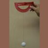
Measuring Wind Speed
Source Institutions
In this indoor and/or outdoor activity, learners make an anemometer (an instrument to measure wind speed) out of a protractor, a ping pong ball and a length of thread or fishing line.
Topographic Investigation: Map an Underwater Surface
Source Institutions
In this activity, learners create a map of a hidden surface using a "sounding stick" -- a technique similar to how underwater maps were once made.
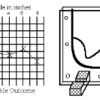
Radar Mapping: What's in the Box?
Source Institutions
In this activity, learners mimic remote sensing. Learners use a stick to measure the distance to a "planet surface" they cannot see, and create their own map of the landscape.