Search Results
Showing results 1 to 7 of 7
Radar Mapping: What's in the Box?
Source Institutions
In this activity, learners mimic remote sensing. Learners use a stick to measure the distance to a "planet surface" they cannot see, and create their own map of the landscape.
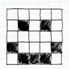
Passion for Pixels
Source Institutions
In this technology activity, learners explore digital imaging and pixels. Learners "transmit" an image to a partner by creating an image on grid paper.
Finding the Size of the Sun and Moon
Source Institutions
In this activity, learners build a simple pinhole viewer. They use this apparatus to project images from a variety of light sources, including a candle, the Sun, and the Moon.

Map That Habitat
Source Institutions
Historically, sea floor mapping (bathymetry) was done by soundings.
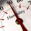
Making Sense of Sensors
Source Institutions
In this activity, learners explore sensors and focus specifically on how to measure humidity using a sensor.
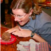
Cook Up a Comet
Source Institutions
In this activity (on page 5 of PDF), learners use dry ice and household materials to make scientifically accurate models of comets.
Making An Impact!
Source Institutions
In this activity (on page 14 of PDF), learners use a pan full of flour and some rocks to create a moonscape.