Source Institutions
Source Institutions
Add to list Go to activity
Activity link broken? See if it's at the internet archive

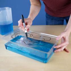
“Exploring Earth: Rising Sea” is a hands-on activity demonstrating ways to use topographical mapping techniques to track changes in sea level. The activity is connected to current NASA research. Together, participants and facilitators can discuss the effects of rising sea levels on coastal communities and the natural environment.
- Under 5 minutes
- 5 to 10 minutes
- free per student
- Ages 6 - 14
- Activity
- English
Quick Guide
Materials List (per student)
- Basin and landform
- Clear acrylic
- Jason-3 satellite model
- Colored dry erase markers
- Eraser
- Large pitcher for water
- Water
- Blue food dye
- Sponge (or paper towels)
- Observing Earth information sheet
- Activity and facilitator guides
- Optional: Tablet or computer to display Jason-3 Mission
- Optional: Tablet or computer to display Images of Change NASA website
Subjects
-
Earth and Space Science
-
Earth Processes
- Geochemical Cycles
- Weather and Climate
-
Earth, Moon and Sun
- Tides
-
Earth Processes
-
The Nature of Science
-
The Scientific Process
- Conducting Investigations
-
The Scientific Process
-
The Nature of Technology
-
Technology and Society
- Technology and the Environment
-
Technology and Society
Other
This resource is part of:
Access Rights:
- Free access
By:
Rights:
- Creative Commons: Non-commercial Share Alike (by-nc-sa), National Informal STEM Education Network, 2017
Funding Source:
- NASA, NNX16AC67A
