Source Institutions
Source Institutions
Add to list Go to activity
Activity link broken? See if it's at the internet archive
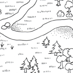
In this outdoor activity, learners use a mapping technique to become oriented to the major features of an outdoor site. Learners become aware of both physical and biological features including trees, rocks, water, signs of human activity. After completing this activity, learners can try the OBIS Terrestrial Hi-Lo Hunt and add more detail to their map.
- 45 to 60 minutes
- 45 to 60 minutes
- $10 - $20 per group of students
- Ages 8 - 18
- Activity, Lesson/Lesson Plan
- English
Quick Guide
Materials List (per group of students)
- map keys on large index cards
- sets of marking pens or crayons or bags of construction paper or contact paper symbols
- sections of outline map
- pencils
- glue sticks or clear tape
- compass
- data board or large drawing pad
- black marking pen
- flagging
Subjects
-
Earth and Space Science
-
Earth Structure
- Rocks and Minerals
- Oceans and Water
-
Earth Structure
-
Life Sciences
-
Diversity of Life
- Plants
- Animals
-
Ecology
- Ecosystems
- Human Impact
-
Diversity of Life
-
The Nature of Science
-
The Scientific Process
- The Scientific Worldview
- Asking Questions
- Formulating Explanations
- Communicating Results
-
The Scientific Process
Informal Categories
- Nature and Environment
- Outdoor Activity
Audience
To use this activity, learners need to:
- see
- see color
- read
- be mobile
- touch
Learning styles supported:
- Involves teamwork and communication skills
- Involves hands-on or lab activities
Other
This resource is part of:
Access Rights:
- Free access
By:
Rights:
- All rights reserved, The Regents of the University of California, 1982