Source Institutions
Source Institutions
Add to list Go to activity
Activity link broken? See if it's at the internet archive
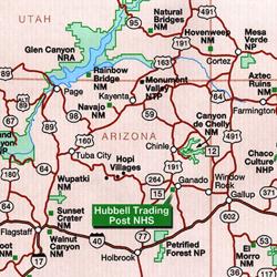
In this mathematics activity, learners use a map to determine the coordinates of and distance between two locations--both by road and "as the crow flies". They account for any differences and convert the distances into feet and inches. This activity provides valuable practice in map skills, measurement, and unit conversion.
- Under 5 minutes
- 10 to 30 minutes
- free per student
- Ages 8 - 11
- Activity
- English
Quick Guide
Materials List (per student)
- Unit conversion tool
- Map of trip (must have a coordinate grid and mileage)
- Pencil
- Paper
Subjects
-
Mathematics
-
Geometry
- Plane Geometry
-
Measurement
- Units of Measurement
- Size and Scale
-
Geometry
Audience
To use this activity, learners need to:
- see
- read
Learning styles supported:
- Uses STEM to solve real-world problems
- Involves hands-on or lab activities