Source Institutions
Source Institutions
Add to list Go to activity
Activity link broken? See if it's at the internet archive
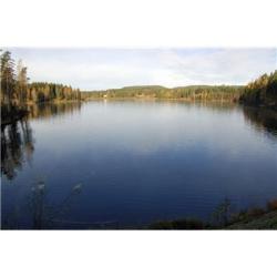
Learners take a field trip along a local body of water and conduct a visual survey to discover information about local land use and water quality. Learners document their findings by mapping and profiling the water body. They can upload their measurements via the internet to a GLOBE scientist. Learners also use this initial investigation to raise questions about local land use and/or water quality issues that may require further study.
- Under 5 minutes
- 1 to 2 hours
- $10 - $20 per group of students
- Ages 11 - 18
- Activity, Experiment/Lab Activity, Field Trip, Lesson/Lesson Plan
- English
Quick Guide
Materials List (per group of students)
- paper
- pencils
- maps and possible satellite images of your body of water
- colored markers
- worksheets
- pH meters
- thermometer
- basic water test kit
Subjects
-
Earth and Space Science
-
Earth Structure
- Rocks and Minerals
- Oceans and Water
- Earth's History
-
Earth Structure
-
Life Sciences
-
Diversity of Life
- Plants
- Animals
-
Ecology
- Ecosystems
- Human Impact
-
Diversity of Life
-
Mathematics
-
Data Analysis and Probability
- Data Analysis
- Data Collection
- Measurement
-
Data Analysis and Probability
-
The Nature of Science
- Science and Society
-
The Scientific Process
- Conducting Investigations
- Gathering Data
- Formulating Explanations
-
The Nature of Technology
-
Technology and Society
- Impacts of Technology
- Technology and the Environment
-
Technology and Society
Informal Categories
- Animals
- Nature and Environment
- Physical Activity
Audience
To use this activity, learners need to:
- see
- see color
- read
- hear
- be mobile
- smell
- touch
Learning styles supported:
- Involves hands-on or lab activities
Other
Components that are part of this resource:
This resource is part of:
Access Rights:
- Free access
By:
- Isaacs, Beth
Rights:
- All rights reserved, Access Excellence @ the National Health Museum, 2009