Search Results
Showing results 1 to 4 of 4
Exploring Earth: Temperature Mapping
Source Institutions
This activity models the way Landsat satellites use a thermal infrared sensor to measure land surface temperatures.
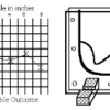
Topographic Investigation: Map an Underwater Surface
Source Institutions
In this activity, learners create a map of a hidden surface using a "sounding stick" -- a technique similar to how underwater maps were once made.
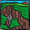
Making Rivers
Source Institutions
In this outdoor water activity, learners explore how to change the direction of water flow. Learners make puddles in dirt or use existing puddles and sticks to make water flow.
Shaking It!
Source Institutions
In this experiment, learners design and build a model room in a shoebox and furnish it with tiny furniture.