Search Results
Showing results 1 to 8 of 8
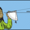
Using a Simple Astrolabe
Source Institutions
In this activity, learners use an astrolabe to measure the altitude of objects. Learners will first practice taking measurements by measuring the altitude of trees and buildings.
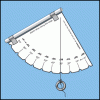
Making a Simple Astrolabe
Source Institutions
In this activity, learners make an astrolabe, a device used for measuring altitude, including the height of objects in the sky.
Exploring Earth: Temperature Mapping
Source Institutions
This activity models the way Landsat satellites use a thermal infrared sensor to measure land surface temperatures.
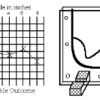
Topographic Investigation: Map an Underwater Surface
Source Institutions
In this activity, learners create a map of a hidden surface using a "sounding stick" -- a technique similar to how underwater maps were once made.
Radar Mapping: What's in the Box?
Source Institutions
In this activity, learners mimic remote sensing. Learners use a stick to measure the distance to a "planet surface" they cannot see, and create their own map of the landscape.
Finding the Size of the Sun and Moon
Source Institutions
In this activity, learners build a simple pinhole viewer. They use this apparatus to project images from a variety of light sources, including a candle, the Sun, and the Moon.
Shaking It!
Source Institutions
In this experiment, learners design and build a model room in a shoebox and furnish it with tiny furniture.
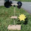
Weather Vane and Anemometer
Source Institutions
In this meteorology activity, learners construct simple devices to measure the direction and speed of wind.