Search Results
Showing results 1 to 3 of 3
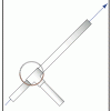
Launch Altitude Tracker
Source Institutions
In this activity, learners construct hand-held altitude trackers. The device is a sighting tube with a marked water level that permits measurement of the inclination of the tube.

Erosion
Source Institutions
In this activity, learners model erosion using a clear shoebox and sand or soil.
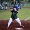
Batter Up!
Source Institutions
This activity (on page 3 of the PDF under GPS: Baseball Activity) is a full inquiry investigation into how "bounciness" relates to the distance a ball will fly when hit off a batting tee.