Search Results
Showing results 1 to 7 of 7
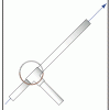
Launch Altitude Tracker
Source Institutions
In this activity, learners construct hand-held altitude trackers. The device is a sighting tube with a marked water level that permits measurement of the inclination of the tube.
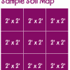
Creating a Soil Map
Source Institutions
In this activity, learners investigate soil conditions by creating a soil map. Learners record soil characteristics and compare the conditions of soil in different grid sections.
Trail Impact Study
Source Institutions
In this outdoor activity, learners plan a simple foot path and create an environmental impact study of the natural area where the path would be.
Erosion
Source Institutions
In this activity, learners model erosion using a clear shoebox and sand or soil.

Floodplain Modeling
In this design-based lesson, learners study flood dynamics as they modify a riverbed with blockages or levees to simulate real-world scenarios.
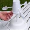
Measuring the Wind
Source Institutions
In this activity, learners explore how anemometers work to record wind speeds and how the equipment has undergone engineering adaptations over time.
My Angle on Cooling: Effects of Distance and Inclination
Source Institutions
In this activity, learners discover that one way to cool an object in the presence of a heat source is to increase the distance from it or change the angle at which it is faced.