Search Results
Showing results 1 to 2 of 2
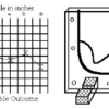
Topographic Investigation: Map an Underwater Surface
Source Institutions
In this activity, learners create a map of a hidden surface using a "sounding stick" -- a technique similar to how underwater maps were once made.
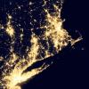
Where Do We Choose to Live and Why?
Source Institutions
In this geography investigation, learners use a nighttime satellite image to observe areas of light across the United States and to identify patterns and spatial distributions of human settlements.