Source Institutions
Source Institutions
Add to list Go to activity
Activity link broken? See if it's at the internet archive

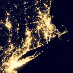
In this geography investigation, learners use a nighttime satellite image to observe areas of light across the United States and to identify patterns and spatial distributions of human settlements. They explain the reasons for these patterns by answering questions and making inferences about what they observe. This detailed lesson guide includes background information, resource links, and handouts.
- Under 5 minutes
- 1 to 2 hours
- 1 cent - $1 per group of students
- Ages 8 - 14
- Activity, Lesson/Lesson Plan
- English
Quick Guide
Materials List (per group of students)
- Briefing and Logs 1, 2, and 2.2
- Figure 2: United States at night puzzle
- Figure 5: United States relief map
- U.S. road/travel map or atlas
- World map or globe
- Overhead transparency sheet
- Overhead markers (light colors)
- Clear cellophane tape
- Scissors
Subjects
-
Earth and Space Science
-
Astronomy
- Probes, Satellites and Spacecraft
-
Earth Processes
- Weather and Climate
-
Astronomy
-
Engineering and Technology
- Technology
-
Life Sciences
-
Ecology
- Populations
-
Ecology
-
Mathematics
-
Algebra
- Patterns
-
Data Analysis and Probability
- Data Analysis
- Data Collection
- Data Representation
- Representation
-
Algebra
-
The Nature of Science
-
The Scientific Process
- Conducting Investigations
- Gathering Data
- Formulating Explanations
- Communicating Results
-
The Scientific Process
Informal Categories
- Nature and Environment
Audience
To use this activity, learners need to:
- see
- see color
- read
- touch
Learning styles supported:
- Involves hands-on or lab activities
Other
Includes alignment to state and/or national standards:
This resource is part of:
Access Rights:
- Free access
By:
Rights:
- Public domain, ,
