Search Results
Showing results 1 to 5 of 5
Dinosaur Interaction
Source Institutions
In this activity, learners explore why animals, specifically dinosaurs, live in families.

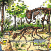
Make a Cast of a Tyrannosaurus rex Fossil
Source Institutions
In this activity, learners explore dinosaur fossils by making cast models of a T. rex. First, learners read about and research how dinosaur fossils form.
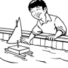
Prepare for a Dock Shop Field Trip
Source Institutions
In this activity, learners explore what makes a boat float and sink. They examine and test various objects to determine why objects float or sink.
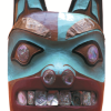
Who Do You Think You Are?
Source Institutions
In this activity, learners use maps to locate the Northwest Coastal region.
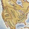
Woodlands Map
Source Institutions
This is a culminating activity which allows learners to summarize what they know about Woodlands Native Americans by creating illustrations and map symbols for a large outline map (see related Activit