Search Results
Showing results 1 to 3 of 3
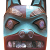
Who Do You Think You Are?
Source Institutions
In this activity, learners use maps to locate the Northwest Coastal region.
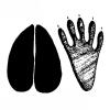
Bring It Home: Animal Tracks
Source Institutions
In this activity, learners create handmade animal track stamps. Learners research animal tracks, draw the shapes on moleskin, and then stick the shapes onto blocks of wood to make stamps.
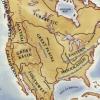
Woodlands Map
Source Institutions
This is a culminating activity which allows learners to summarize what they know about Woodlands Native Americans by creating illustrations and map symbols for a large outline map (see related Activit