Search Results
Showing results 1 to 10 of 10
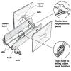
My Angle on Cooling: Effects of Distance and Inclination
Source Institutions
In this activity, learners discover that one way to cool an object in the presence of a heat source is to increase the distance from it or change the angle at which it is faced.
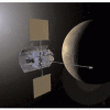
Postcards from Space
Source Institutions
Using information from the My Place in Space lithograph, learners write and/or draw a postcard to friends and family as if they had gone beyond the interstellar boundary of our Solar System, into the
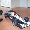
Out of Sight: Remote Vehicle Activity
Source Institutions
In this robotics activity, learners drive a remote-controlled car through a course to learn the challenges faced while trying to operate a planetary rover.
Kepler Paper Model
Source Institutions
In this activity, learners build a paper model of the spacecraft and photometer (telescope) used during NASA's Kepler Mission.
Roving on the Moon
Add to list DetailsIn this design challenge activity, learners build a rubber band-powered rover that can scramble across the room.
We Have Capture!
Source Institutions
Using simple materials, learners will construct the end effector (grasping device) of a robotic arm and use the device to capture and pick up an object.
Getting There!: Navigation and Trajectory
Source Institutions
In this two-part activity, learners map a navigation plan to get from Earth to Mars and back. In activity one, learners represent the orbital paths of Earth through dance and dramatic movement.
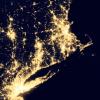
Where Do We Choose to Live and Why?
Source Institutions
In this geography investigation, learners use a nighttime satellite image to observe areas of light across the United States and to identify patterns and spatial distributions of human settlements.
Proportionality: The X-Plane Generation
Source Institutions
In this activity, learners build a 1:140 "scale model" of NASA's X-33 Reusable Launch Vehicle (RLV) Technology Demonstrator, and investigate how the model dimensions compare to the real vehicle.
Paint by the Numbers
Source Institutions
In this pencil and paper activity, learners work in pairs and simulate how astronomical spacecraft and computers create images of objects in space.