Source Institutions
Source Institutions
Add to list Go to activity
Activity link broken? See if it's at the internet archive
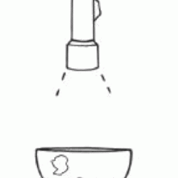
In this activity about cartography, learners work in teams to create two different map projections: a planar (or polar) and a cylindrical (or Mercator) projection. Learners construct an imaginary polar continent from a soda bottle and shine a flashlight directly above it to make a projection. They trace this projection onto a piece of paper to create the planar projection. They then use another portion of the bottle to create the cylindrical projection. This activity will help learners understand the challenges of creating maps of the Earth.
- Under 5 minutes
- 45 to 60 minutes
- 1 cent - $1 per group of students
- Ages 11 - 18
- Activity
- English
Quick Guide
Materials List (per group of students)
- 1 clear plastic 2-liter soda bottle
- sharp knife (optional)
- 1 flashlight
- 1 marker or grease pencil
- journal
- scissors
- 1 ruler or tape measure
- 2 sheets of tracing paper
- tape
Subjects
-
Earth and Space Science
- Earth Structure
-
Engineering and Technology
-
Technology
- Information and Communication
-
Technology
-
Mathematics
-
Measurement
- Size and Scale
-
Measurement
-
The Nature of Technology
-
Technology and Society
- Impacts of Technology
-
Technology and Society
Audience
To use this activity, learners need to:
- see
- read
- touch
Learning styles supported:
- Involves teamwork and communication skills
- Involves hands-on or lab activities
Other
This resource is part of:
Access Rights:
- Free access
By:
Rights:
- All rights reserved, American Museum of Natural History and Rice University, 2002