Search Results
Showing results 1 to 20 of 32
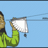
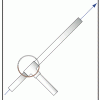
Using a Simple Astrolabe
Source Institutions
In this activity, learners use an astrolabe to measure the altitude of objects. Learners will first practice taking measurements by measuring the altitude of trees and buildings.
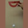
Measuring Wind Speed
Source Institutions
In this indoor and/or outdoor activity, learners make an anemometer (an instrument to measure wind speed) out of a protractor, a ping pong ball and a length of thread or fishing line.
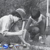
Trail Construction
Source Institutions
In this highly physical outdoor activity, learners construct and compare experimental trail sections to select the best trail-construction technique for their site.
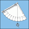
Making a Simple Astrolabe
Source Institutions
In this activity, learners make an astrolabe, a device used for measuring altitude, including the height of objects in the sky.
Exploring Earth: Temperature Mapping
Source Institutions
This activity models the way Landsat satellites use a thermal infrared sensor to measure land surface temperatures.

Map That Habitat
Source Institutions
Historically, sea floor mapping (bathymetry) was done by soundings.
Launch Altitude Tracker
Source Institutions
In this activity, learners construct hand-held altitude trackers. The device is a sighting tube with a marked water level that permits measurement of the inclination of the tube.
Model Wind Tunnel
Source Institutions
In this activity, learners build a miniature wind tunnel to measure force. Learners construct the model out of Lexan plastic, a fan, and a precise digital scale.
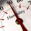
Making Sense of Sensors
Source Institutions
In this activity, learners explore sensors and focus specifically on how to measure humidity using a sensor.
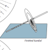
Equatorial Sundial
Source Institutions
In this activity, learners make an equatorial sundial, which is simple to construct and teaches fundamental astronomical concepts. Learners use the provided template and a straw to build the sundial.
Measuring the Wind
Source Institutions
In this activity, learners explore how anemometers work to record wind speeds and how the equipment has undergone engineering adaptations over time.
Topographic Investigation: Map an Underwater Surface
Source Institutions
In this activity, learners create a map of a hidden surface using a "sounding stick" -- a technique similar to how underwater maps were once made.
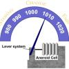
Measure the Pressure II: The "Dry" Barometer
Source Institutions
In this activity, learners use simple items to construct a device for indicating air pressure changes.
Finding the Size of the Sun and Moon
Source Institutions
In this activity, learners build a simple pinhole viewer. They use this apparatus to project images from a variety of light sources, including a candle, the Sun, and the Moon.
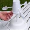
Twirling in the Breeze
Source Institutions
In this engineering activity, learners build a device (an anemometer) to measure how fast the wind is blowing.
Sand Castle Saturation
Source Institutions
In this activity about saturation (page 1 of PDF under SciGirls Activity: Sand Dunes), learners will build a series of sand castle towers using a 16 oz cup.
Shaking It!
Source Institutions
In this experiment, learners design and build a model room in a shoebox and furnish it with tiny furniture.
How Big is Small
Source Institutions
In this classic hands-on activity, learners estimate the length of a molecule by floating a fatty acid (oleic acid) on water.
Gravity Fountains
Source Institutions
This activity (located on page 3 of the PDF under GPS: Glaciers Activity) is a full inquiry investigation into the forces of gravity and air pressure.
Dunking the Planets
Source Institutions
In this demonstration, learners compare the relative sizes and masses of scale models of the planets as represented by fruits and other foods.