Search Results
Showing results 1 to 5 of 5
Exploring Earth: Temperature Mapping
Source Institutions
This activity models the way Landsat satellites use a thermal infrared sensor to measure land surface temperatures.

Cutting it Down to Nano
Source Institutions
This simple activity uses paper and scissors to convey two key concepts to learners: the nanoscale is very small and working on the nanoscale requires special tools.
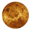
Radar Mapping: What's in the Box?
Source Institutions
In this activity, learners mimic remote sensing. Learners use a stick to measure the distance to a "planet surface" they cannot see, and create their own map of the landscape.
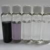
Exploring Size: Scented Solutions
Source Institutions
This is an activity in which learners will find that they can detect differences in concentration better with their nose (smelling) than with their eyes (seeing).
Shaking It!
Source Institutions
In this experiment, learners design and build a model room in a shoebox and furnish it with tiny furniture.