Search Results
Showing results 1 to 6 of 6
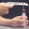
Hot Sauce Hot Spots
Source Institutions
In this activity, learners model hot spot island formation, orientation and progression with condiments.

To Topo Two
Source Institutions
In this activity, two groups of learners create two separate landform models out of clay (mountains and valleys).
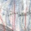
A Crayon Rock Cycle- Metamorphic
Source Institutions
This is part 2 of the three-part "Crayon Rock Cycle" activity and must be done after part 1: Sedimentary Rocks. In this activity, learners explore how metamorphic rocks form.
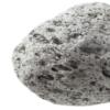
A Crayon Rock Cycle - Igneous
Source Institutions
This is part 3 of the three-part "Crayon Rock Cycle" activity. Before starting this section, learners must have completed part 1: sedimentary rock and part 2: metamorphic rocks.
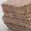
A Crayon Rock Cycle- Sedimentary
Source Institutions
This is part 1 of the three-part "Crayon Rock Cycle" activity. In this activity, learners explore how sedimentary rocks form.

Exploring Earth: Temperature Mapping
Source Institutions
This activity models the way Landsat satellites use a thermal infrared sensor to measure land surface temperatures.