Source Institutions
Source Institutions
Add to list Go to activity
Activity link broken? See if it's at the internet archive
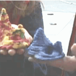
In this activity, two groups of learners create two separate landform models out of clay (mountains and valleys). Each group creates a two-dimensional model (a topographical map) of their landform on a sheet of paper. Topo maps are then switched. Each group then recreates the other group's landform. Then all models are compared.
- Under 5 minutes
- 45 to 60 minutes
- $1 - $5 per group of students
- Ages 8 - 18
- Activity, Lesson/Lesson Plan, Model
- English
Quick Guide
Materials List (per group of students)
- Synthetic clay (Plasticine or Play-doh)
- Paper
- Pencil
- Two meter sticks (or slates of wood about 1/4 in thick)
- Strong thin wire (to cut the clay)
Subjects
-
Earth and Space Science
- Earth Structure
-
Mathematics
- Geometry
- Measurement
- Representation
-
Physical Sciences
-
Heat and Thermodynamics
- Heat and Temperature
-
Heat and Thermodynamics
-
The Nature of Science
-
The Scientific Process
- Conducting Investigations
- Gathering Data
- Communicating Results
-
The Scientific Process
Informal Categories
- Model Building
- Nature and Environment
Audience
To use this activity, learners need to:
- see
- read
- touch
Learning styles supported:
- Involves teamwork and communication skills
- Involves hands-on or lab activities
Other
This resource is part of:
Access Rights:
- Free access
By:
- Muller, Eric
Rights:
- All rights reserved, Exploratorium, 1998