Search Results
Showing results 1 to 6 of 6
Lava Layering: Making and Mapping a Volcano
Source Institutions
In this activity, learners discover how geologists use stratigraphy, the study of layered rock, to understand the sequence of geological events.
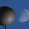
Why Does the Moon Have Phases?
Source Institutions
In this activity, learners use a simple 3D model to discover why the Moon has phases.
Getting There!: Navigation and Trajectory
Source Institutions
In this two-part activity, learners map a navigation plan to get from Earth to Mars and back. In activity one, learners represent the orbital paths of Earth through dance and dramatic movement.

To Topo Two
Source Institutions
In this activity, two groups of learners create two separate landform models out of clay (mountains and valleys).
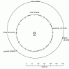
The Thousand-Yard Model
Source Institutions
This is a classic exercise for visualizing the scale of the Solar System.

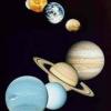
Scale Models
Source Institutions
In this activity, learners explore the relative sizes and distances of objects in the solar system.