Search Results
Showing results 1 to 6 of 6
Tropical Belt
Source Institutions
This lesson familiarizes learners with the term "tropical belt." First, learners locate the equator, Tropic of Cancer and Tropic of Capricorn on a map and trace these lines with a crayon.

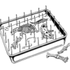
Tomb Mapping
Source Institutions
In this activity, learners examine the culture and history of the tomb site.
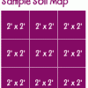
Creating a Soil Map
Source Institutions
In this activity, learners investigate soil conditions by creating a soil map. Learners record soil characteristics and compare the conditions of soil in different grid sections.
Classroom Dinosaur Dig
Source Institutions
In this activity, learners participate in a simulated dig to discover fossilized dinosaur bones. Learners take notes, make a map and propose theories about dinosaurs.
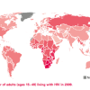
Mapping the Spread of HIV/AIDS: Trailing the Pandemic
Source Institutions
In this activity, learners act as epidemiologists by mapping the prevalence of HIV/AIDS worldwide.

Aerial Imagery
Source Institutions
This activity (on page 2 of the PDF under SciGirls Activity: Earthquakes) is a full inquiry investigation into aerial imagery.