Search Results
Showing results 1 to 9 of 9
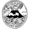
Lava Layering: Making and Mapping a Volcano
Source Institutions
In this activity, learners discover how geologists use stratigraphy, the study of layered rock, to understand the sequence of geological events.
The Poor Cartographer: Graph Coloring
Source Institutions
In this activity, learners help a poor cartographer color in the countries on a map, making sure each country is colored a different color than any of its neighbors.

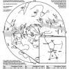
Drawing Conclusions
Source Institutions
In this weather forecasting activity, learners determine the location of cold and warm fronts on weather plot maps.
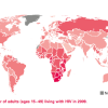
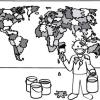
Mapping the Spread of HIV/AIDS: Trailing the Pandemic
Source Institutions
In this activity, learners act as epidemiologists by mapping the prevalence of HIV/AIDS worldwide.
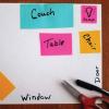
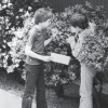
Make A Map for A Treasure Hunt
Source Institutions
In this activity, learners will explore how maps can provide information about a place and help us find our way from one location to another.
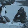
Plant Patterns
Source Institutions
In this outdoor mapping activity, learners explore where plants grow and map plant-distribution patterns.
Plants Around a Building
Source Institutions
In this outdoor activity, learners discover how the environment around a building affects the growth of plants.

To Topo Two
Source Institutions
In this activity, two groups of learners create two separate landform models out of clay (mountains and valleys).
Supernova Star Maps
Source Institutions
This fun astronomy activity allows learners to experience finding stars in the night sky that will eventually go supernova. This activity is perfect for a star party outdoors.