Search Results
Showing results 1 to 8 of 8
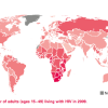
Mapping the Spread of HIV/AIDS: Trailing the Pandemic
Source Institutions
In this activity, learners act as epidemiologists by mapping the prevalence of HIV/AIDS worldwide.
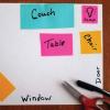
Make A Map for A Treasure Hunt
Source Institutions
In this activity, learners will explore how maps can provide information about a place and help us find our way from one location to another.
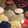
Spice World
Source Institutions
In this activity, learners create a map showing the origins of spices and herbs from a favorite recipe(s). Learners first research the origins of the ingredients and then locate them on a world map.
Plants Around a Building
Source Institutions
In this outdoor activity, learners discover how the environment around a building affects the growth of plants.
Tropical Belt
Source Institutions
This lesson familiarizes learners with the term "tropical belt." First, learners locate the equator, Tropic of Cancer and Tropic of Capricorn on a map and trace these lines with a crayon.

To Topo Two
Source Institutions
In this activity, two groups of learners create two separate landform models out of clay (mountains and valleys).
If Anyone Can, Icon
Source Institutions
In this activity, learners create their own icons for a forecast-at-a-glance poster for their classroom/learning space.
Where on Earth?
Source Institutions
Learners look at labels on items in the room to determine where each item was manufactured, then write about the item on an index card.