Search Results
Showing results 1 to 7 of 7
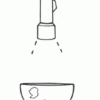
Making Map Projections
Source Institutions
In this activity about cartography, learners work in teams to create two different map projections: a planar (or polar) and a cylindrical (or Mercator) projection.

Tomb Mapping
Source Institutions
In this activity, learners examine the culture and history of the tomb site.
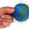
Polar Opposites
Source Institutions
In this activity, learners make a 3-D model of magnetic fields by inserting a small, strong magnet into a sphere.
Tsunami: Waves of Destruction
Source Institutions
In this activity, learners use tsunami time travel maps to predict how long it will take a tsunami to reach the shore.

Using Different Models of Earth
Source Institutions
In this activity, learners explore how the shapes, sizes, and distances of land masses appear differently on two different models of Earth: an icosahedron and a flat map.
Tropical Belt
Source Institutions
This lesson familiarizes learners with the term "tropical belt." First, learners locate the equator, Tropic of Cancer and Tropic of Capricorn on a map and trace these lines with a crayon.
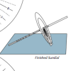
Equatorial Sundial
Source Institutions
In this activity, learners make an equatorial sundial, which is simple to construct and teaches fundamental astronomical concepts. Learners use the provided template and a straw to build the sundial.