Search Results
Showing results 1 to 3 of 3
Wind Mapping with Bubbles
Source Institutions
Discover the wind's direction using bubbles, a map and a keen eye. Learners blow bubbles and note their general direction on a map, taking readings from different points around a building.
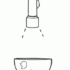
Making Map Projections
Source Institutions
In this activity about cartography, learners work in teams to create two different map projections: a planar (or polar) and a cylindrical (or Mercator) projection.
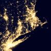
Where Do We Choose to Live and Why?
Source Institutions
In this geography investigation, learners use a nighttime satellite image to observe areas of light across the United States and to identify patterns and spatial distributions of human settlements.