Search Results
Showing results 1 to 5 of 5
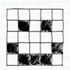
Passion for Pixels
Source Institutions
In this technology activity, learners explore digital imaging and pixels. Learners "transmit" an image to a partner by creating an image on grid paper.
Locating a Point
Source Institutions
In this activity, learners work in teams to simulate the process used by Global Positioning Systems (GPS) to determine the location of a fallen meteorite in Antarctica.
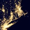
Where Do We Choose to Live and Why?
Source Institutions
In this geography investigation, learners use a nighttime satellite image to observe areas of light across the United States and to identify patterns and spatial distributions of human settlements.

Aerial Imagery
Source Institutions
This activity (on page 2 of the PDF under SciGirls Activity: Earthquakes) is a full inquiry investigation into aerial imagery.
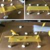
DIY Pasta Rover
Source Institutions
In this activity, learners design and build a NASA rover using raw pasta and candy with a limited imaginary budget.