Search Results
Showing results 1 to 20 of 39
Lava Layering: Making and Mapping a Volcano
Source Institutions
In this activity, learners discover how geologists use stratigraphy, the study of layered rock, to understand the sequence of geological events.
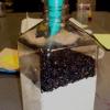
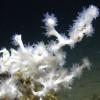
Avalanche
Source Institutions
In this geology activity, learners create a model using a mixture of salt and sand inside a CD case. When the case is tilted or inverted, the mixture dramatically sorts into a layered pattern.
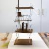
Engineering For Earthquakes
Source Institutions
In this design challenge, learners will engineer a structure and see if it can survive an earthquake they create.
Why Doesn’t the Ocean Freeze?
Source Institutions
In this activity, learners explore how salt water freezes in comparison to fresh water.
My Angle on Cooling: Effects of Distance and Inclination
Source Institutions
In this activity, learners discover that one way to cool an object in the presence of a heat source is to increase the distance from it or change the angle at which it is faced.

Erosion
Source Institutions
In this activity, learners model erosion using a clear shoebox and sand or soil.

Floodplain Modeling
In this design-based lesson, learners study flood dynamics as they modify a riverbed with blockages or levees to simulate real-world scenarios.
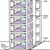
Earthquake-Proof Buildings
Source Institutions
In this geology and engineering activity (page 7 of the PDF), learners build an earthquake simulator, then use it to test various building designs, exploring different materials, shapes, and design op
Conductivity: Salty Water
Source Institutions
Water, whether fresh or salty, serves as one of the best electrical conductors on the planet. Does salt effect its conductivity?
Earth Atmosphere Composition
Source Institutions
In this activity, learners use rice grains to model the composition of the atmosphere of the Earth today and in 1880. Learners assemble the model while measuring percentages.
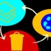
Trash Talkin'
In this activity, learners collect, categorize, weigh and analyze classroom trash and discuss ways that engineers have helped to reduce solid waste.
House Warming
Source Institutions
In this physical sciences activity, learners explore how passive solar design increases energy efficiency.
Haunted by Hurricanes: Use Data to Learn About Hurricanes
Source Institutions
In this activity, learners will determine if the frequency and intensity of hurricanes are changing using real data from the National Hurricane Center.
The Return of El Nino
Source Institutions
In this activity related to climate change and data analysis, learners examine temperature and precipitation data to determine if climate variations are due to El Niño.
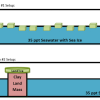
Causes and Effects of Melting Ice
Source Institutions
In this activity, learners explore the concept of density-driven currents (thermohaline circulation) and how these currents are affected by climate change.
Trail Impact Study
Source Institutions
In this outdoor activity, learners plan a simple foot path and create an environmental impact study of the natural area where the path would be.
Off Base
Source Institutions
In this activity, learners explore the factors that tend to resist changes in pH of the ocean and why the ocean is becoming more acidic.
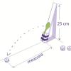
Volcanic Material Catapult Investigation
Source Institutions
This activity (located on page 3 of the PDF under GPS: Lava Flow Activity) is a full inquiry investigation into the relationship between an object’s mass and the distance it is thrown by a catapult.
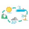
Water Cycle in a Bag
Source Institutions
In this activity, learners will explore the water cycle by creating a small atmosphere.
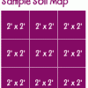
Creating a Soil Map
Source Institutions
In this activity, learners investigate soil conditions by creating a soil map. Learners record soil characteristics and compare the conditions of soil in different grid sections.