Source Institutions
Source Institutions
Add to list Go to activity
Activity link broken? See if it's at the internet archive
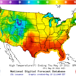
In this activity, learners create their own weather forecast map. Learners will visit the National Weather Service Southern Region website and use the zip code search feature to gather data and complete a temperature forecast map. Use this activity to discuss weather forecasting and climate trends throughout the US.
- Under 5 minutes
- 30 to 45 minutes
- free per student
- Ages 8 - 14
- Activity, Lesson/Lesson Plan
- English
Quick Guide
Subjects
-
Earth and Space Science
-
Earth Processes
- Weather and Climate
-
Earth Processes
-
Engineering and Technology
-
Computing
- Information Technology
-
Technology
- Information and Communication
-
Computing
-
Mathematics
-
Data Analysis and Probability
- Data Analysis
- Data Collection
- Data Representation
- Probability
- Representation
-
Data Analysis and Probability
-
Physical Sciences
-
Heat and Thermodynamics
- Heat and Temperature
-
Heat and Thermodynamics
-
The Nature of Science
-
The Scientific Process
- Conducting Investigations
- Gathering Data
- Communicating Results
-
The Scientific Process
Informal Categories
- Computers
- Nature and Environment
Audience
To use this activity, learners need to:
- see
- read
- use keyboard
- use mouse
- touch
Learning styles supported:
- Involves hands-on or lab activities
Other
Components that are part of this resource:
This resource is part of:
Access Rights:
- Free access
By:
Rights:
- All rights reserved, National Weather Service,