Source Institutions
Source Institutions
Add to list Go to activity
Activity link broken? See if it's at the internet archive
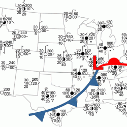
In this weather forecasting activity, learners determine the location of cold and warm fronts on weather plot maps. Learners use colored pencils to mark up and analyze surface pressure, air temperature, dewpoint, and pressure change on different maps. Learners will discover how forecasters label and extrapolate information from weather maps. This resource includes analysis and discussion questions and solutions. This resource also includes tips about flood safety.
- Under 5 minutes
- 45 to 60 minutes
- free per student
- Ages 8 - 18
- Activity, Lesson/Lesson Plan
- English
Quick Guide
Materials List (per student)
Subjects
-
Earth and Space Science
-
Earth Processes
- Weather and Climate
-
Earth Structure
- Atmosphere
-
Earth Processes
-
Mathematics
-
Data Analysis and Probability
- Data Analysis
- Data Collection
- Data Representation
- Probability
-
Measurement
- Units of Measurement
- Representation
-
Data Analysis and Probability
-
The Nature of Technology
-
The Design Process
- Problem Solving
-
The Design Process
-
Physical Sciences
-
Heat and Thermodynamics
- Heat and Temperature
-
Motion and Forces
- Momentum and Velocity
-
States of Matter
- Changes of Phase
-
Heat and Thermodynamics
-
The Nature of Science
-
The Scientific Process
- Conducting Investigations
- Gathering Data
- Communicating Results
-
The Scientific Process
Informal Categories
- Nature and Environment
Audience
To use this activity, learners need to:
- see
- see color
- read
- touch
Learning styles supported:
- Involves hands-on or lab activities
Other
Components that are part of this resource:
- Turn Around, Don't Drown Homepage
- Real-time weather observation plots
- Surface Pressure Map Solutions
- Surface Temperature Map Solutions
- Dewpoint Temperature Map Solutions
This resource is part of:
Access Rights:
- Free access
By:
Rights:
- All rights reserved, National Weather Service,