Search Results
Showing results 1 to 9 of 9
Fragile Waters
Source Institutions
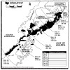
In this activity (on pages 18-29) learners explore the impact of the March 24, 1989 oil spill in Alaska caused by the Exxon Valdez tanker.
Particle Detection
Source Institutions
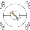
By tossing, collecting, and sorting beanbags, learners understand how the IBEX spacecraft uses its sensors to detect and map the locations of particle types in the interstellar boundary.
Green Travelers
Source Institutions
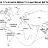
In this activity (on pages 23-29), partners use the Plant Traveler Cards, along with a world map and map worksheets, to follow plants such as cassava, chocolate and coffee that grew first in one part

Energy Use in the Americas
Source Institutions
Learners explore the relationship between energy consumption, population, and carbon emissions in the countries of the Americas.
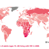
Mapping the Spread of HIV/AIDS: Trailing the Pandemic
Source Institutions
In this activity, learners act as epidemiologists by mapping the prevalence of HIV/AIDS worldwide.
Make A Map for A Treasure Hunt
Source Institutions
In this activity, learners will explore how maps can provide information about a place and help us find our way from one location to another.

Where in the World is the Terra Cotta Army?
Source Institutions
In this activity, learners find Xi'an, the archaeological area in China where the Terra Cotta Army was discovered, on a map or globe and look more closely at the relationship of the warrior site to ot

Aerial Imagery
Source Institutions
This activity (on page 2 of the PDF under SciGirls Activity: Earthquakes) is a full inquiry investigation into aerial imagery.
Tropical Belt
Source Institutions
This lesson familiarizes learners with the term "tropical belt." First, learners locate the equator, Tropic of Cancer and Tropic of Capricorn on a map and trace these lines with a crayon.