Search Results
Showing results 1 to 5 of 5
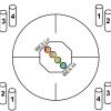
Particle Detection
Source Institutions
By tossing, collecting, and sorting beanbags, learners understand how the IBEX spacecraft uses its sensors to detect and map the locations of particle types in the interstellar boundary.

Using Different Models of Earth
Source Institutions
In this activity, learners explore how the shapes, sizes, and distances of land masses appear differently on two different models of Earth: an icosahedron and a flat map.

Map That Habitat
Source Institutions
Historically, sea floor mapping (bathymetry) was done by soundings.
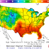
Forward Thinking
Source Institutions
In this activity, learners create their own weather forecast map.

Aerial Imagery
Source Institutions
This activity (on page 2 of the PDF under SciGirls Activity: Earthquakes) is a full inquiry investigation into aerial imagery.