Search Results
Showing results 1 to 20 of 69
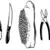
Fossilized Dinosaur Teeth Adaptations
Source Institutions
In this activity, learners use models of fossilized dinosaur teeth to understand how dinosaur teeth were used.
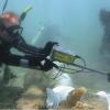
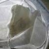
Excavating and Mapping Under Water
Source Institutions
In this archaeology activity, learners consider ways in which excavating an underwater site is different from excavating a terrestrial site.
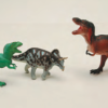
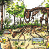
Join the Dinosaur Age
Source Institutions
In this activity, learners rotate through several learning and play stations to explore dinosaurs and paleontologists.
Mercury in the Environment
Source Institutions
In this environmental science lesson, learners will examine the dangers of mercury and how humans contribute to growing mercury emissions on Earth.
Start a Rock Collection
Source Institutions
Learners follow a three-step process to start their own rock collection.
Glaciers
Source Institutions
In this online activity, learners adjust mountain snowfall and temperature to see how glaciers grow and shrink. They will use scientific tools to measure thickness, velocity and glacial budget.
Kelsey: Clues of the Dig Site Map
Source Institutions
In this activity, learners explore dinosaur fossils and a dig site. Learners work in groups to analyze a dig site map and match bones to a skeletal drawing of Kelsey (a Triceratops).
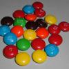
Radioactive Decay of Candium
Source Institutions
In this simulation, learners use M&M™ candy to explore radioactive isotope decay.

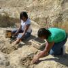
Do Your Own Dig
Source Institutions
In this outdoor archaeology activity, learners use mathematical skills and scientific inquiry to generate and process information from their own excavation site.

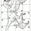
Make a Dinosaur Model
Source Institutions
In this activity, learners explore dinosaur skeletons, anatomy, and locomotion. Learners compare and contrast dinosaur skeletons and drawings.
Relative Speed of Dinosaurs
Source Institutions
In this activity, learners interpret three trackways and use measurements and a formula to infer the relative speed of dinosaurs.
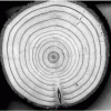
Trees: Recorders of Climate Change
Source Institutions
In this activity, learners are introduced to tree rings by examining a cross section of a tree, also known as a “tree cookie.” They discover how tree age can be determined by studying the rings and ho
Shoebox Dinosaur Dig Site
Source Institutions
In this activity, (on page 6 of the PDF under SciGirls Activity: Dinosaurs) learners participate in a hands-on fossil excavation.
Big Time Tour
Source Institutions
In this activity (on pages 16-21), learners get a sense of geological time by understanding how big a million is.

How Big Were the Dinosaurs?
Source Institutions
In this activity (located on page 4 of PDF), learners gain insight into the actual size of dinosaurs and practice making estimations and measurements.
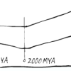
Prehistoric Climate Change
Source Institutions
In this online interactive, learners use fossils to infer temperatures 55 million years ago, at the sites where the fossils were found.
Dinosaur Interaction
Source Institutions
In this activity, learners explore why animals, specifically dinosaurs, live in families.
Collect Invertebrates to Determine Water Quality
Source Institutions
This activity (located on page 3 of the PDF under GPS: Alligator Habitat Activity) is a full inquiry investigation into organisms and the health of their ecosystems.
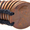
Penny Rubbing
Source Institutions
In this art-related activity, learners make a coin rubbing—a process similar to what archeologists may do with ancient artifacts. This activity can be used in connection with a history or art lesson.
Smaller Than You Think
Source Institutions
Learners compare a life-size drawing of a Tyrannosaurus rex head and a full-size Sinornithosaurus body to understand that dinosaurs varied in size.