Search Results
Showing results 1 to 13 of 13
Lava Layering: Making and Mapping a Volcano
Source Institutions
In this activity, learners discover how geologists use stratigraphy, the study of layered rock, to understand the sequence of geological events.
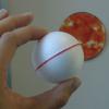
Hot Sauce Hot Spots
Source Institutions
In this activity, learners model hot spot island formation, orientation and progression with condiments.
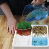
Exploring Earth: Land Cover
Source Institutions
This activity models some of the ways natural processes, such as erosion and sediment pollution, affect Earth’s landscape.

Exploring the Universe: Static Electricity
Source Institutions
This activity encourages visitors to build an electroscope—a simplified version of one of the tools scientists use to study the invisible forces on Earth and in space.

To Topo Two
Source Institutions
In this activity, two groups of learners create two separate landform models out of clay (mountains and valleys).
A Crayon Rock Cycle- Metamorphic
Source Institutions
This is part 2 of the three-part "Crayon Rock Cycle" activity and must be done after part 1: Sedimentary Rocks. In this activity, learners explore how metamorphic rocks form.
A Crayon Rock Cycle - Igneous
Source Institutions
This is part 3 of the three-part "Crayon Rock Cycle" activity. Before starting this section, learners must have completed part 1: sedimentary rock and part 2: metamorphic rocks.
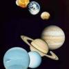
The Thousand-Yard Model
Source Institutions
This is a classic exercise for visualizing the scale of the Solar System.
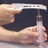
Ice on Mars
Source Institutions
In this activity, learners use sand and ice cubes to create a model of permafrost and the effects of the ice melting through the surface.
A Crayon Rock Cycle- Sedimentary
Source Institutions
This is part 1 of the three-part "Crayon Rock Cycle" activity. In this activity, learners explore how sedimentary rocks form.
Eclipse: How can the little Moon hide the giant Sun?
Source Institutions
In this activity, learners explore how distance can affect the way we perceive the size of an object.

Exploring Earth: Temperature Mapping
Source Institutions
This activity models the way Landsat satellites use a thermal infrared sensor to measure land surface temperatures.

Scale Models
Source Institutions
In this activity, learners explore the relative sizes and distances of objects in the solar system.